

Collection: Osher Collection
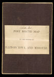
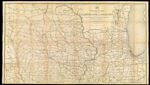
Name: Post Route Map of the states of Illinois, Iowa and Missouri with adjacent parts of Indiana, Wisconsin,, Minnesota, Nebraska, Kansas and Arkansas showing post distances and routes in operation on the 1st of December 1884.
Barcode:
Image Number:
Creator:
Date/Date Range Produced:
Date/Date Range Published:
Language:
Dimensions: folded to 20 x 14 cm.
Notes: Handwritten on cover: "Northern Part" and the number "7".
Physical Description: Mounted on linen.
OCLC: 884820580
Accession Number: OS-1884-50
Donor:
Permanent URL: